First Modern Bathymetric Map (10 feb 1872 año – 11 jul 1878 año)
Descripción:
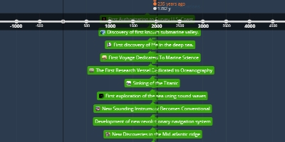
New high density soundings were taken by the coast survey streamer blake in the gulf of mexico. This event is important because it is the first time the bathyspheric map is almost perfected.Añadido al timeline:
fecha:
10 feb 1872 año
11 jul 1878 año
~ 6 years and 4 months
