33
/fr/
AIzaSyAYiBZKx7MnpbEhh9jyipgxe19OcubqV5w
October 1, 2025
Create a timeline
Public Timelines
For education
For educational institutions
For teachers
For students
Cabinet
For educational institutions
For teachers
For students
Open cabinet
FAQ
Obtenir le Premium
Close
Create a timeline
Public timelines
Library
FAQ
About & Feedback
Un accord
Confidentialité
Bibliothèque
FAQ
Support 24/7
Cabinet
Get premium
Donate
The service accepts bank transfer (ACH, Wire) or cards (Visa, MasterCard, etc). Processed by Stripe.
Secured with SSL
Éditer
Télécharger
Export
Créer une copie
Premium
Intégrer dans le site Web
Share
GIS industry timeline Thailand
Category:
Autre
mise à jour avec succès:
1 juil. 2024
0
0
87
Auteurs
Created by
M.L. Saksiri Kridakorn
Attachments
Comments
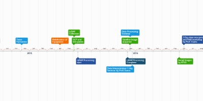
Phanom Rung Project Timeline
By
M.L. Saksiri Kridakorn
28 déc. 2017
0
0
760
Lidar archeology Phanom Rung
By
M.L. Saksiri Kridakorn
28 déc. 2017
0
0
457
191 timeline
By
M.L. Saksiri Kridakorn
22 nov. 2020
0
0
223
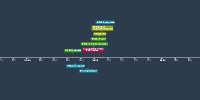
History of GIS Thailand
By
M.L. Saksiri Kridakorn
1 juil. 2024
0
0
75
Les événements
RTSD เริ่มการผลิตแผนที่ดิจิทัล
แผนที่ดิจิทัลแห่งแรกของกรุงเทพฯ ในราคา 191 (LBS แรกในเอเชีย)
QGIS V1
OGC Open Geospatial Consortium
1:4.000 แผนที่ดิจิทัลแห่งแรกของประเทศไทยจาก VHR IKONOS
ORFEO Toolbox for remote sensing
GITHUB
Theos 1
Thailand NSDI
Microsoft เข้าซื้อกิจการ GITHub
Low Cost Commerical satellite imagery market
Artificial Intelligence for image processing
ระบบข้อมูลที่ดินกรุงเทพมหานคร BLIS
ภาพจาก Theos 2?
การใช้งานโอเพ่นซอร์สอย่างกว้างขวาง
Périodes
การเรียนรู้เทคโนโลยี GIS
การสร้างการแปลงและการป้อนข้อมูล
อินเทอร์เน็ตและแผนที่ออนไลน์
About & Feedback
Un accord
Confidentialité
Bibliothèque
FAQ
Support 24/7
Cabinet
Get premium
Donate
The service accepts bank transfer (ACH, Wire) or cards (Visa, MasterCard, etc). Processed by Stripe.
Secured with SSL

Comments